Current Missions
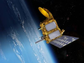
Cryosat-2
ESA’s CryoSat-2 mission was launched in 2010 with the primary purpose of monitoring the cryosphere system. The satellite is characterized by a Low-Earth, non- Sun-Syncronous orbit, with an altitude of circa 730 km and coverage of ±88° (92° inclination). Its repeating cycle is of 369 days, with 30-day sub-cycles. The sophisticated design of the onboard SAR/Interferometric Radar ALtimeter (SIRAL) allows applications also on inland water and ocean, with promising results on coastal areas. SIRAL operates in three different modes, namely Low Resolution Mode (LRM), Synthetic Aperture Radar (SAR) and Inteferometric SAR (SARIn). The geographical extent of each mode is determined by a dynamic global mask, which changes according to the presence of ice - in the interested areas - or eventually to user requests. [More]
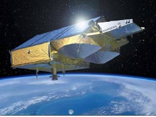 Cryosat-2 (Credit: ESA)
HY-2B
HY-2B (Haiyang-2B) is a Chinese oceanographic satellite developed by the China National Space Administration (CNSA) and the State Oceanic Administration (SOA). Launched in 2014, the satellite is designed to monitor and study the world`s oceans, with a focus on measuring sea surface height, wind speed and direction, and ocean surface temperature. These measurements are critical for understanding ocean dynamics, including the formation and movement of ocean currents, and the transport of heat and salt in the oceans. The data collected by the HY-2B satellite also helps to improve our understanding of the ocean`s role in climate change and provides valuable information for marine resource management and disaster warning systems. The HY-2B satellite continues to play a significant role in advancing China`s capabilities in oceanography and space technology. [More]

HY-2C
HY-2C (Haiyang-2C) is a Chinese oceanographic satellite developed by the China National Space Administration (CNSA) and the State Oceanic Administration (SOA). It was launched in 2020 with the primary aim of monitoring and studying the oceans, including their topography, temperature, and salinity levels. The satellite is equipped with a synthetic aperture radar (SAR) system that provides high-resolution images and measurements of the ocean`s surface, making it possible to track changes in sea level, waves, and currents. Additionally, HY-2C also supports research in areas such as climate change, disaster warning, and marine environment monitoring. The satellite plays a critical role in advancing China`s capabilities in oceanography and space technology. [More]
HY-2D
Description not yet available! [More]

IceSAT-2
ICESat-2 (Ice, Cloud, and land Elevation Satellite 2) is a satellite mission developed by NASA to study Earth`s polar ice, including glaciers, sea ice, and ice sheets in Greenland and Antarctica. Launched in 2018, the satellite is equipped with a laser instrument known as the Advanced Topographic Laser Altimeter System (ATLAS), which provides highly accurate measurements of ice surface elevation. These measurements are critical for understanding how ice sheets and glaciers are changing over time and the impacts of these changes on sea level rise. The data collected by ICESat-2 also helps to improve our understanding of the Earth`s cryosphere, or frozen regions, and the role they play in the Earth`s climate system. ICESat-2 continues the legacy of the original ICESat mission, providing critical data for scientific research and policy decision making related to climate change and its impacts on the planet. [More]
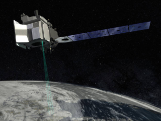 IceSAT-2 (Credit: NASA)
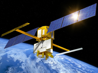
Jason-3
Jason-3 is the third satellite of the Jason series. It was launched in January 2016 and it is currently monitoring the ocean surface on the same ground-track as TOPEX/Poseidon, Jason-1, and Jason-2. Such ground-track configuration has allowed a continuous monitoring of the oceans, providing data with an uninterrupted timeseries of circa 25 years. [More]
 Jason-3 (Credit: NASA)
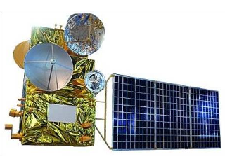
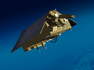
SARAL
SARAL is a mission born from the collaboration between CNES and ISRO. SARAL was launched in 2013 with the objective of monitoring the ocean surface. For this purpose, SARAL carries two fundamental instruments: a receiver for the ARGO float system (link to ARGO), the ARGOS-3, and the first altimeter operating in Ka band, namely AltiKa. The High frequency of Ka band improves the accuracy in range measurements as well as measurements over ice and coastal areas. SARAL flies in a LEO, Sun-synchronous, polar orbit at 800 km of altitude, and with a repeat cycle of 35 days. [More]
 SARAL/AltiKa (Credit: CNES)
Sentinel-3A
The Sentinel satellites are designed within the European Commission Copernicus programme, whose aim is to monitor our planet for environmental, social, and economic purposes. The Sentinel-3 series is focused on ocean observation, with further applications also on land and atmosphere. The mission is based on two identical satellites flying on a polar, Sun-synchronous orbit at altitude 815 km, inclination of 98.6° and a repeat cycle of 27 days. The first satellite, Sentinel-3A was launched in February 2016. [More]
 Sentinel-3A (Credit: ESA)
Sentinel-3B
The Sentinel satellites are designed within the European Commission Copernicus programme, whose aim is to monitor our planet for environmental, social, and economic purposes. The Sentinel-3 series is focused on ocean observation, with further applications also on land and atmosphere. The mission is based on two identical satellites flying on a polar, Sun-synchronous orbit at altitude 815 km, inclination of 98.6° and a repeat cycle of 27 days. The first satellite, Sentinel-3A was launched in February 2016. [More]
 Sentinel-3B (Credit: ESA)
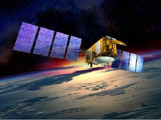
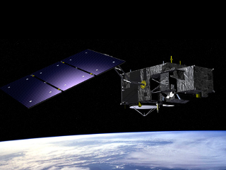
Sentinel-6A
Sentinel-6A, also known as Jason-CS A, is a European Space Agency (ESA) and National Aeronautics and Space Administration (NASA) satellite mission designed to study sea level and ocean circulation. Launched in 2020, the Sentinel-6A satellite carries a suite of advanced instruments, including radar altimeters and radiometers, to measure the height of the ocean surface with high accuracy. These measurements are critical for understanding how sea level is changing over time and the impacts of these changes on coastal communities, ecosystems, and the global climate. The data collected by Sentinel-6A also helps to improve our understanding of ocean circulation and its role in regulating the Earth`s climate. The Sentinel-6A mission is part of the European Copernicus program, a global network of satellites dedicated to monitoring and studying the Earth`s environment. [More]
 Sentinel-6A (Credit: ESA)
SWOT
SWOT (Surface Water and Ocean Topography) is an international satellite mission aimed at studying the world`s oceans and freshwater bodies. Launched in 2022, the SWOT satellite was developed as a collaboration between NASA and the French space agency CNES (Centre National d`Etudes Spatiales). The satellite carries a Ka-band radar system that will measure ocean height with high accuracy, providing information about ocean currents, waves, and tides. The SWOT mission will also make the first global survey of the world`s lakes, rivers, and wetlands, providing important data on their extent, variability, and changes over time. This information will be critical in understanding and managing water resources, predicting floods, and mitigating the impacts of climate change. The SWOT satellite will revolutionize our understanding of the world`s oceans and freshwater systems and play a key role in advancing our knowledge of Earth`s water cycle. [More]
 SWOT (Credit: CNES)