Ocean Tides
Estimation of ocean tides at DGFI-TUM is done using multi-mission satellite altimetry and in-situ tide gauge observations. These data can be used to understand the dynamics of ocean tides, to inform ocean tide models, or as corrections for remote sensing applications. Additionally, at DGFI-TUM, significant research has been done about ocean tides across the land-ocean continuum. For more information: https://dahiti.dgfi.tum.de/en/products/river-tides/
Empirical Ocean Tide Model
Multi-mission satellite altimetry is used to derive global Empirical Ocean Tide (EOT) models. These models provide tidal constituents used for tidal predictions and corrections across a wide range of geodetic applications, particularly satellite altimetry. The main objective of the current versions of the model is to provide highly accurate tide estimates in the coastal zone to improve coastal altimetry applications at DGFI-TUM and across the scientific community. More information on model versions, EOT20 and EOT11, can be found at: https://openadb.dgfi.tum.de/en/products/empirical-ocean-tide-model/

Figure 1: Amplitude of the M2 tidal constituent from EOT20.
TIdal CONstants database
The estimation of TIdal CONstants (TICON) is done globally based on in-situ tide gauge observations from GESLA-4. These data can be used to produce local tidal predictions of the ocean tidal heights, important for navigation and flood forecasting. Additionally, these data are crucial for validating global tidal modelling efforts by the community, as conducted at DGFI-TUM.
An interactive map can be found here.
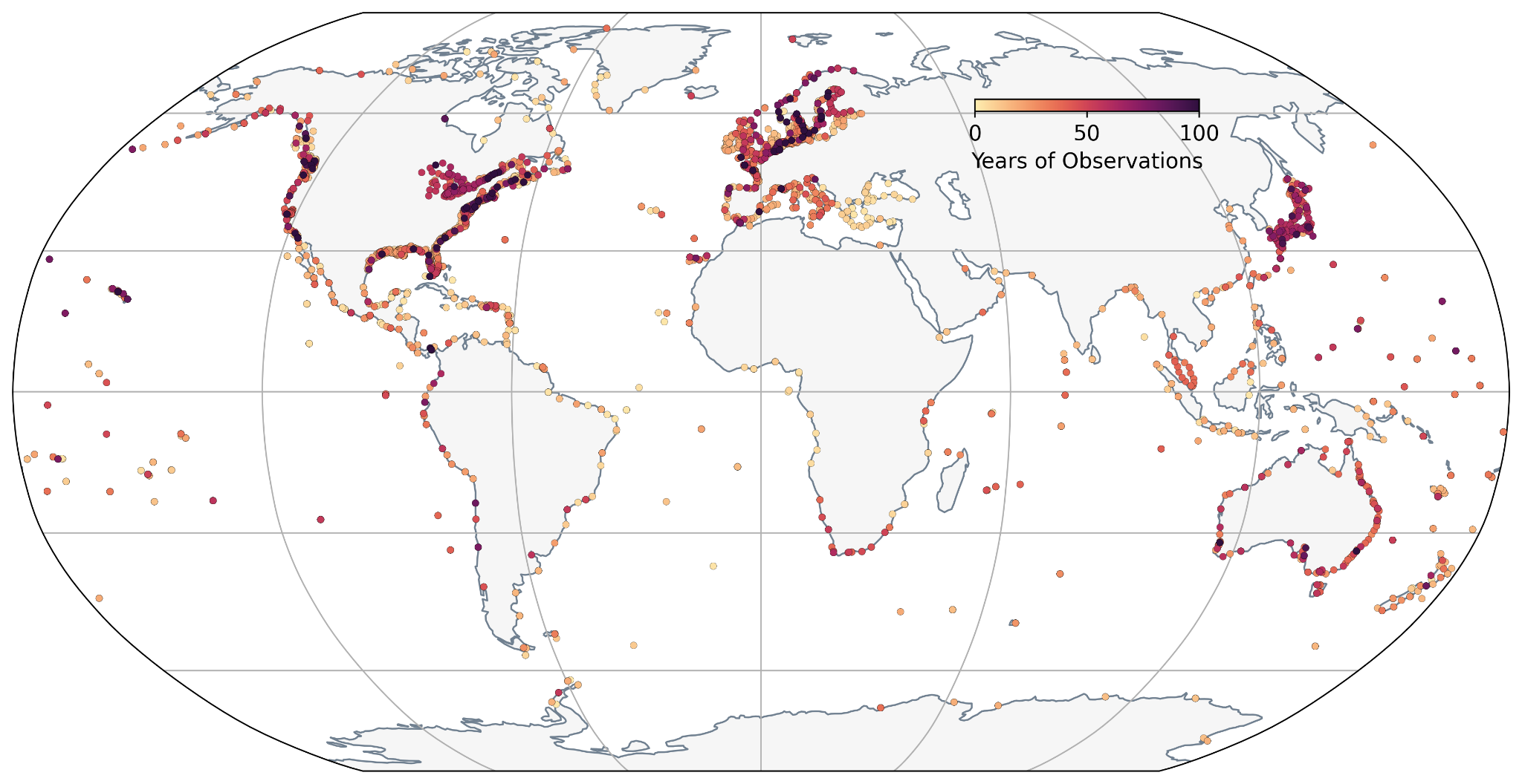
Figure 2: Map of the number of years of observations of data used within TICON-4.
Data access: https://www.seanoe.org/data/00980/109129/
Tidal Datums
Using the TICON database, tidal datums are provided to describe tidal characteristics across the global coastal zone. This information is critical for local communities, such as fishermen and the shipping industry, but also for the scientific community across biogeochemical disciplines. At DGFI-TUM several datums are provided, including maximum tidal range, tidal duration and tidal trends.
An interactive map can be found here.

Figure 3: Tidal range from all tide gauges within TICON-4.
Data access: https://www.seanoe.org/data/01005/111620/
References
Hart-Davis, M. G., Piccioni, G., Dettmering, D., Schwatke, C., Passaro, M., and Seitz, F.: EOT20: a global ocean tide model from multi-mission satellite altimetry, Earth Syst. Sci. Data, 13, 3869-3884, https://doi.org/10.5194/essd-13-3869-2021, 2021
Hart-Davis M., Dettmering D., Seitz F.: TICON-4: TIdal CONstants based on GESLA-4 sea-level records. SEANOE. https://doi.org/10.17882/109129, 2025.
Hart-Davis, M., Sulzbach, R. and Talke, S.: Tidal characteristics from tide gauge data. SEANOE. https://doi.org/10.17882/111620, 2026
Hart-Davis, M. G., Sulzbach, R. L., Talke, S. A., Haigh, I. D., Marcos, M., Woodworth, P., Ray, R., Andersen, O. B., Lyard, F., Fouchet, E., Dettmering, D., Thomas, M., and Seitz, F.: Tide of the Time: Global tidal characteristics observed from in-situ measurements, EGUsphere [preprint], https://doi.org/10.5194/egusphere-2026-346, 2026
Hart-Davis M.G., Scherer D., Schwatke C., Sawyer A., Pavelsky T., Ray R.D., Matte P., Dettmering D, Seitz F.: Observing the tidal pulse of rivers from wide-swath satellite altimetry. Nature. https://doi.org/10.1038/s41586-026-10287-z, 2026