ICESat-2 (Ice, Cloud, and land Elevation Satellite 2) is a satellite mission developed by NASA to study Earth`s polar ice, including glaciers, sea ice, and ice sheets in Greenland and Antarctica. Launched in 2018, the satellite is equipped with a laser instrument known as the Advanced Topographic Laser Altimeter System (ATLAS), which provides highly accurate measurements of ice surface elevation. These measurements are critical for understanding how ice sheets and glaciers are changing over time and the impacts of these changes on sea level rise. The data collected by ICESat-2 also helps to improve our understanding of the Earth`s cryosphere, or frozen regions, and the role they play in the Earth`s climate system. ICESat-2 continues the legacy of the original ICESat mission, providing critical data for scientific research and policy decision making related to climate change and its impacts on the planet.
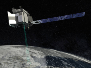 IceSAT-2 (Credit: NASA)